

Garmin 010C101920 G3 Hxca600x – Canada 4665474
Original price was: $183.92.$95.99Current price is: $95.99.
- Quality products, fair prices.
- Safe Payments for a Better Shopping Experience
- SSL encryption, absolutely safe shopping
- Buy quality, buy with us.

Description
This item is brand-new, factory sealed.
BlueChart® g2 HD – HXCA015R – Canada – microSD™/SD™
Coverage:
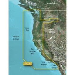
Provides detailed coastal coverage of the North America East Coast from Nain, NL to Raritan Bay, NY featuring Newfoundland, Ile d’Anticosti, New York Harbor, and full US and Canadian coverage of the Great Lakes in their entirety. The North American West Coast is covered from Glacier Bay, AK to Aberdeen, WA featuring British Columbia, Vancouver, the Queen Charlotte Islands, and Puget Sounds.
Improve your view with 1-foot HD contours
- Detailed nautical charts derived from government charts and private sources to provide port plans, depth contours, navigational aids, and tides and currents in a seamless chart presentation
- Vector object oriented data
- Shaded depth contours and intertidal zones with spot soundings
- Worldwide coverage available in regionalized cuts
- 1-foot HD contours provide a more accurate depiction of bottom structure for improved fishing charts and navigation in swamps, canals and port plans
See your vessel’s precise position on-chart in relation to navaids, spot soundings, coastal features, anchorages, port plans, waterways, obstructions, restricted areas and more. BlueChart® g2 HD provides seamless chart presentation with 1-foot HD contours to provide a more accurate depiction of bottom structure for improved fishing charts and navigation in swamps, canals, marinas and port plans. Coverage is available worldwide in regional offerings for Garmin handhelds and chartplotters.
Improve Your View
BlueChart g2 HD marine maps feature crisp labeling and an exceptionally smooth presentation on your chartplotter display.
In addition to the basic charts, tidal stations, currents, depth contours, IALA symbols and included full bathymetric fishing charts with detailed contours, BlueChart g2 HD also offers smooth transitioning between zoom levels and seamless continuity across chart boundaries.
Customize Your Screens
BlueChart g2 HD also adds Shallow Water Shading to allow the user to enable contour shading for all depth contours shallower than the user-defined safe depth.
The fishing charts are designed to emphasize bathymetric contours with less visual clutter on the display.
There’s also a choice of standard 2-D direct overhead or 3-D “over-the-bow” map views for easier chart reading and orientation.
Bluechart g2 HD charts also provide shaded depth contours and intertidal zones with spot soundings. Detailed port plans to help you find your way in and out, plus marina points of interest and slipways. Tidal stations and tidal current graphs for selected countries. Aids to navigation with view range and coverage, including light sector information. Wrecks, restricted areas, anchorages and obstructions are clearly identified. You also have both 2-D or 3-D map perspective views.
Features:
- Up to 1-foot HD fishing contours
- Seamless chart presentation
- Vector object-oriented data
- Shaded depth contours and intertidal zones with spot soundings
- Port plans
- Tidal stations for selected countries
- Aids to navigation with view range and coverage, including light sectors information
- Wrecks, restricted areas, anchorages, obstructions
- Tidal current graphs
- 2-D or 3-D map perspective view
- Marina points of interest and slipways
- Full bathymetric fishing charts providing detailed contours
*Some BlueChart products may contain C-MAP by Jeppesen data.© 2016 Jeppesen. All rights reserved.
Package Contents:
- BlueChart g2 Land/Marine Map
- SD Card Adapter
Features
- BlueChart g2 Land/Marine Map
- SD Card Adapter
Additional Information:
- Includes realistic navigation features showing everything from shaded depth contours and coastlines to spot soundings, navaids, port plans, wrecks, obstructions, intertidal zones, restricted areas, IALA symbols and more
- Features smooth displays, including seamless transitions between zoom levels and more continuity across chart boundaries
- Allows users to choose between standard 2-D direct overhead or 3-D “over the bow” map perspective to make chart reading and orientation easier
- Provides Safety Shading (in compatible units), allowing mariners to enable contour shading for all depth contours shallower than user-defined safe depths
- Provides Fishing Charts (in compatible units), allowing mariners to scope out bottom contours and depth soundings with less visual clutter on the display
- Allows users to conveniently plan and organize routes, from your computer, before your trip with HomePort, compatible trip-planning software (sold separately)
Compatibility:
Garmin Navigators:
- Astro 320
- Colorado 300
- Colorado 400c
- Colorado 400i
- Colorado 400t
- Dakota 20
- eTrex 20
- eTrex 30
- GPSMAP 4008
- GPSMAP 4010
- GPSMAP 4012
- GPSMAP 420/420s
- GPSMAP 4208
- GPSMAP 421
- GPSMAP 4210
- GPSMAP 4212
- GPSMAP 421s
- GPSMAP 430/430s
- GPSMAP 431
- GPSMAP 431s
- GPSMAP 440/440s
- GPSMAP 441
- GPSMAP 441s
- GPSMAP 5008
- GPSMAP 5012
- GPSMAP 5015
- GPSMAP 520/520s
- GPSMAP 5208
- GPSMAP 521
- GPSMAP 5212
- GPSMAP 5215
- GPSMAP 521s
- GPSMAP 525/525s
- GPSMAP 526
- GPSMAP 526s
- GPSMAP 530/530s
- GPSMAP 531
- GPSMAP 531s
- GPSMAP 535/535s
- GPSMAP 536
- GPSMAP 536s
- GPSMAP 540/540s
- GPSMAP 541
- GPSMAP 541s
- GPSMAP 545/545s
- GPSMAP 546
- GPSMAP 546s
- GPSMAP 6008
- GPSMAP 6012
- GPSMAP 60CSx
- GPSMAP 60Cx
- GPSMAP 620
- GPSMAP 6208
- GPSMAP 6212
- GPSMAP 62s
- GPSMAP 62sc
- GPSMAP 62st
- GPSMAP 62stc
- GPSMAP 640
- GPSMAP 7012
- GPSMAP 7015
- GPSMAP 720
- GPSMAP 720s
- GPSMAP 7212
- GPSMAP 7215
- GPSMAP 740
- GPSMAP 740s
- GPSMAP 76CSx
- GPSMAP 76Cx
- GPSMAP 78
- GPSMAP 78s
- GPSMAP 78sc
- Montana 600
- Montana 650
- Montana 650t
- nüvi 500
- nüvi 550
- Oregon 200
- Oregon 300
- Oregon 400c
- Oregon 400i
- Oregon 400t
- Oregon 450
- Oregon 450t
- Oregon 550
- Oregon 550t
- Rino 520HCx
- Rino 530HCx
- Rino 650
- Rino 655t
Specs
| General Information | |
| Brand Name | Garmin |
| Manufacturer Website Address | http://www.garmin.com |
| Marketing Information | See your vessel’s precise, on-chart position in relation to navaids, coastal features, anchorages, obstructions, waterways, restricted areas and more with this detailed marine mapping data. Also includes Safety Shading and Fishing Charts (in compatible units), smooth data transition between zoom levels, harmonious transition across chart borders and reduction of chart discontinuities in coverage areas. |
| Product Type | Land/Marine Map |
| Product Name | BlueChart g2 Land/Marine Map |
| Manufacturer | Garmin, Ltd |
| Manufacturer Part Number | 010-C1019-20 |
| Product Line | BlueChart |
| Product Information | |
| Continent | North America |
| State/Province/Territory |
|
| Marine |
|
| Country |
|
| Distribution Medium Type | microSD |
| City |
|
View AllClose
| Brand Name | Garmin |
|---|---|
| Manufacturer Website Address | |
| Marketing Information | See your vessel's precise, on-chart position in relation to navaids, coastal features, anchorages, obstructions, waterways, restricted areas and more with this detailed marine mapping data. Also includes Safety Shading and Fishing Charts (in compatible units), smooth data transition between zoom levels, harmonious transition across chart borders and reduction of chart discontinuities in coverage areas. |
| Product Type | Land/Marine Map |
| Product Name | BlueChart g2 Land/Marine Map |
| Manufacturer | Garmin, Ltd |
| Manufacturer Part Number | 010-C1019-20 |
| Product Line | BlueChart |
| Continent | North America |
| State/Province/Territory | Newfoundland |
| Marine | Raritan Bay |
| Country | United States |
| Distribution Medium Type | microSD |
| City | Vancouver |
Be the first to review “Garmin 010C101920 G3 Hxca600x – Canada 4665474”
Related products

Car & Vehicle Electronics
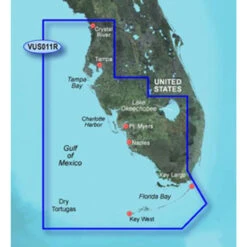
Garmin BlueChart G2 Vision: Southwest Florida Digital Map (3930368)

Car & Vehicle Electronics
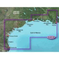
Garmin BlueChart G2 Vision Morgan City Brownsville Digital Map (3930372)
Car & Vehicle Electronics
Car & Vehicle Electronics

Car & Vehicle Electronics
Car & Vehicle Electronics
Car & Vehicle Electronics
Car & Vehicle Electronics
Reviews
There are no reviews yet.