
 1")
 2")
 3")
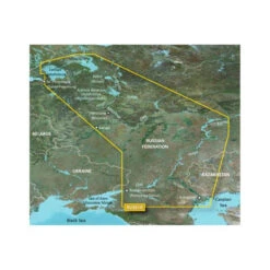
Garmin HXRU001R Russian Inland Waterways Digital Map (010-c1048-20)
Original price was: $113.10.$79.17Current price is: $79.17.
- Quality products, fair prices.
- Safe Payments for a Better Shopping Experience
- SSL encryption, absolutely safe shopping
- Buy quality, buy with us.

Description
This item is brand-new, factory sealed.
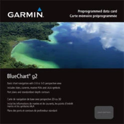
BlueChart® g2 HD – HXEU062R – Russian Inland Waterways – microSD™/SD™
Coverage:
This Cyrillic data card details main channel coverage of the major river systems and lakes of western Russia. Detailed coverage includes the Don R. from the Sea of Azov (Azovskoe More) to the Tsimlyanskoe Reservoir (Tsimlyansk Vodokhranilishche); the Volga-Don Canal (Volgo-Donskoy Kanal) to the Volga R. which is shown in its entirety; the Kama R. from Tyul’kino to the Volga R.; the Vishera R. from Ryabinino to the junction with the Kama R.; the Oka R. from Kaluga to its junction with the Moskva R; the Sheksna R. in its entirety; Lake Beloe (Beloye Ozero); the Volga-Baltic Canal (Volgo-Baltiyskiy Kanal); Lake Onega (Onezhskoe Ozero); the Svir R. to Lake Ladoga (Ladozhskoye Ozero); and the Neva R. to St. Petersburg (Sankt-Peterburg). Also included are the Volga-Baltic Waterway including the Rybinsk Reservoir (Rybinskoye Vodokhranilishche), the entire White Sea-Baltic Canal, and Lakes Onega (Onezhskoe), Ladoga (Ladozhskoye), and Beloe (Beloye).
Improve your view with 1-foot HD contours
- Detailed nautical charts derived from government charts and private sources to provide port plans, depth contours, navigational aids, and tides and currents in a seamless chart presentation
- Vector object oriented data
- Shaded depth contours and intertidal zones with spot soundings
- Worldwide coverage available in regionalized cuts
- 1-foot HD contours provide a more accurate depiction of bottom structure for improved fishing charts and navigation in swamps, canals and port plans
See your vessel’s precise position on-chart in relation to navaids, spot soundings, coastal features, anchorages, port plans, waterways, obstructions, restricted areas and more. BlueChart® g2 HD provides seamless chart presentation with 1-foot HD contours to provide a more accurate depiction of bottom structure for improved fishing charts and navigation in swamps, canals, marinas and port plans. Coverage is available worldwide in regional offerings for Garmin handhelds and chartplotters.
Improve Your View
BlueChart g2 HD marine maps feature crisp labeling and an exceptionally smooth presentation on your chartplotter display.
In addition to the basic charts, tidal stations, currents, depth contours, IALA symbols and included full bathymetric fishing charts with detailed contours, BlueChart g2 HD also offers smooth transitioning between zoom levels and seamless continuity across chart boundaries.
Customize Your Screens
BlueChart g2 HD also adds Shallow Water Shading to allow the user to enable contour shading for all depth contours shallower than the user-defined safe depth.
The fishing charts are designed to emphasize bathymetric contours with less visual clutter on the display.
There’s also a choice of standard 2-D direct overhead or 3-D “over-the-bow” map views for easier chart reading and orientation.
Bluechart g2 HD charts also provide shaded depth contours and intertidal zones with spot soundings. Detailed port plans to help you find your way in and out, plus marina points of interest and slipways. Tidal stations and tidal current graphs for selected countries. Aids to navigation with view range and coverage, including light sector information. Wrecks, restricted areas, anchorages and obstructions are clearly identified. You also have both 2-D or 3-D map perspective views.
Features:
- Up to 1-foot HD fishing contours
- Seamless chart presentation
- Vector object-oriented data
- Shaded depth contours and intertidal zones with spot soundings
- Port plans
- Tidal stations for selected countries
- Aids to navigation with view range and coverage, including light sectors information
- Wrecks, restricted areas, anchorages, obstructions
- Tidal current graphs
- 2-D or 3-D map perspective view
- Marina points of interest and slipways
- Full bathymetric fishing charts providing detailed contours
*Some BlueChart products may contain C-MAP by Jeppesen data.© 2016 Jeppesen. All rights reserved.
Features
- Realistic navigation features
- Smooth display presentation
- Safety shading
- Fishing charts
- Choice of standard 2-D direct overhead or 3-D
Compatibility:
- Colorado 300
- Colorado 400c
- Colorado 400i
- Colorado 400t
- Dakota 20
- GPSMAP 6012
- GPSMAP 6212
- GPSMAP 7212
- GPSMAP 4008
- GPSMAP 4010
- GPSMAP 4012
- GPSMAP 420/420s
- GPSMAP 4208
- GPSMAP 421/421s
- GPSMAP 4210
- GPSMAP 4212
- GPSMAP 430/430s
- GPSMAP 431/431s
- GPSMAP 440/440s
- GPSMAP 441/441s
- GPSMAP 5008
- GPSMAP 5012
- GPSMAP 5015
- GPSMAP 520/520s
- GPSMAP 5208
- GPSMAP 521/521s
- GPSMAP 5212
- GPSMAP 5215
- GPSMAP 525/525s
- GPSMAP 526/526s
- GPSMAP 530/530s
- GPSMAP 531/531s
- GPSMAP 535/535s
- GPSMAP 536/536s
- GPSMAP 540/540s
- GPSMAP 541/541s
- GPSMAP 545/545s
- GPSMAP 546/546s
- GPSMAP 6008
- GPSMAP 60CSx
- GPSMAP 60Cx
- GPSMAP 620
- GPSMAP 6208
- GPSMAP 62s
- GPSMAP 62st
- GPSMAP 640
- GPSMAP 7012
- GPSMAP 7015
- GPSMAP 720/720s
- GPSMAP 7215
- GPSMAP 740/740s
- GPSMAP 76CSx
- GPSMAP 76Cx
- GPSMAP 78
- GPSMAP 78s
- GPSMAP 78sc
- nüvi 500
- nüvi 550
- Oregon 200
- Oregon 300
- Oregon 400c
- Oregon 400i
- Oregon 400t
- Oregon 450
- Oregon 450t
- Oregon 550
- Oregon 550t
- Rino 520HCx
- Rino 530HCx
Specs
| General Information | |
| Brand Name | Garmin |
| Manufacturer Website Address | http://www.garmin.com |
| Marketing Information | See your surroundings more clearly with BlueChart g2 data. With BlueChart g2, you’ll get detailed marine cartography that provides convenient viewing of nautical content. BlueChart g2 allows you to see your vessel’s precise, on-chart position in relation to navaids, coastal features, anchorages, obstructions, waterways, restricted areas and more. You also will have access to detailed mapping capabilities that include safety shading, fishing charts, smooth data transition between zoom levels, harmonious transition across chart borders, and reduction of chart discontinuities. |
| Product Type | Marine Map |
| Product Name | HXRU001R Russian Inland Waterways Digital Map |
| Manufacturer | Garmin, Ltd |
| Manufacturer Part Number | 010-C1048-20 |
| Product Model | HXRU001R |
| Product Information | |
| Continent | Europe |
| Marine |
|
| Application/Usage |
|
| Country | Russia |
| Distribution Medium Type | microSD |
View AllClose
| Brand Name | Garmin |
|---|---|
| Manufacturer Website Address | |
| Marketing Information | See your surroundings more clearly with BlueChart g2 data. With BlueChart g2, you'll get detailed marine cartography that provides convenient viewing of nautical content. BlueChart g2 allows you to see your vessel's precise, on-chart position in relation to navaids, coastal features, anchorages, obstructions, waterways, restricted areas and more. You also will have access to detailed mapping capabilities that include safety shading, fishing charts, smooth data transition between zoom levels, harmonious transition across chart borders, and reduction of chart discontinuities. |
| Product Type | Marine Map |
| Product Name | HXRU001R Russian Inland Waterways Digital Map |
| Manufacturer | Garmin, Ltd |
| Manufacturer Part Number | 010-C1048-20 |
| Product Model | HXRU001R |
| Continent | Europe |
| Marine | Inland Lake |
| Application/Usage | Boating |
| Country | Russia |
| Distribution Medium Type | microSD |
Be the first to review “Garmin HXRU001R Russian Inland Waterways Digital Map (010-c1048-20)”
Related products
Car & Vehicle Electronics
Car & Vehicle Electronics
Car & Vehicle Electronics

Car & Vehicle Electronics
Garmin 010C077700 G3v Veu021r – Denmark E & Sweden Se 3930689

Car & Vehicle Electronics
Garmin Dual Beam Transducer – Trolling, Transom – Plastic 0101024920

Car & Vehicle Electronics
![Garmin Stainless Steel Thru-hull Mount Transducer With Depth & Temperature [20° Tilt] - Airmar SS60 (010-11868-22)](https://www.thegarmingps.com/wp-content/uploads/2024/04/010-11868-22__48757.1694252536-247x247.webp)
Car & Vehicle Electronics
Car & Vehicle Electronics
Reviews
There are no reviews yet.