


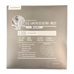

Garmin LakeVu G3 Ultra West
Original price was: $169.95.$98.99Current price is: $98.99.
- Quality products, fair prices.
- Safe Payments for a Better Shopping Experience
- SSL encryption, absolutely safe shopping
- Buy quality, buy with us.

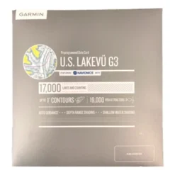
Garmin LakeVu G3 Ultra with Navionics Data
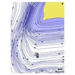
Get a new perspective on navigation with Garmin LakeVu g3 Ultra West Inland Lake cartography.Integrated Garmin and Navionics content provide coverage for over 18,000 lakes, over 16,000 in high definition and 167 Garmin Elite survey lakes. LakeVu g3 Ultra maps provide Surface and side scan sonar photos of 122 lakes- giving users unparalled Lake detail. The Garmin LakeVu g3 Ultra map card provides the following mapping features in addition to high resolution satellite imagery, navigational aids, spot soundings, tides and currents. Simply plug the SD card into your compatible Garmin MFD and enjoy the benefits of Garmin g3 Mapping.
Auto Guidance Technology– Will search the attributes of all relevant charts to suggest the best course for navigation taking into consideration your desired safe depth and overhead clearance.
Depth Range Shading– For up to 10 depths so you can view your designated target depth
Shallow Water Shading– Allows for user defined depths, showing a clear picture of shallow waters to avoid
High Resolution Relief Shading– Combines color and shadow to provide an easy to read view of bottom structure than contour lines alone. View a list of lakes with high-resolution relief shading here.
Unique 3D Views– MarinerEye and FishEye views provide detailed contours below the water line
Dynamic Lake Levels-Adjust your maps to the lakes current water level to better understand areas that are too shallow or easily accessible at the current moment
here to view a list of compatible units.
The Garmin LakeVu g3 Ultra West card covers over 18,000 of US inland lakes with up to 1-foot contours, and more than 167 Garmin Elite survey lakes. Both East and West LakeVu g3 Ultra Charts include Minnesota, Iowa, Missouri, Arkansas, and Louisiana.
Be the first to review “Garmin LakeVu G3 Ultra West”
Related products
GPS Maps & Software
GPS Maps & Software

GPS Maps & Software


GPS Maps & Software


GPS Maps & Software

GPS Maps & Software
GPS Maps & Software
GPS Maps & Software
Reviews
There are no reviews yet.